GIS 4035 - Module 1 - Visual Interpretation

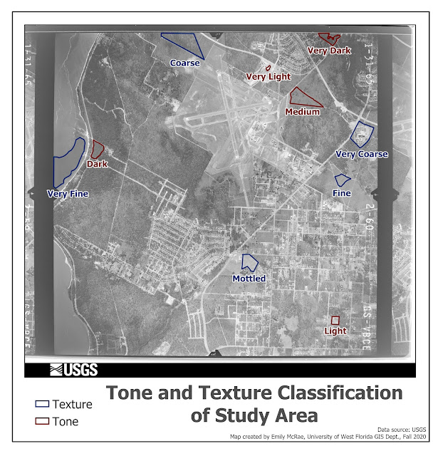
This map demonstrates, through a grey scale aerial image, how one can classify features on a landscape visually using tone and texture. Tone being the scale of lightness to darkness and texture being a scale of very coarse to very fine. These classifications were done by eye, and may be subjective to the analysts interpretation, as well as the images clarity, scale, and resolution.
This map identifies features in a greyscale aerial photo by 4 means: pattern (Objects/places were chosen that are clearly visible and interpretable as they are part of a larger repeating pattern, but that had they been presented in isolation or at a very large scale, would not be clear as to what they are), shadows (Objects were chosen which could not have been identified had they not been casting a shadow which revealed information about what the object is), association (Objects were chosen that could not be identified without looking at the surrounding environment and making logical connections about what the object might be, given its proximity to other identifiable objects), and shape/size (Objects were chosen which could be identified solely off of their individual appearance and not using any other contextual clues in the image). This process demonstrates these techniques for feature identification on an image. This method is subjective to the analysts interpretation, as well as the images scale, resolution, and in the case of shadows, the declination of the sun.


Comments

Popular posts from this blog

GIS6005 - Module 1 San Francisco Bay Area, Point of Interest

GIS 5100 Module 2

GIS 5100 Module 6